Haiti security intelligence, district by district
What Sentry View monitors in Haiti, how the country is divided on the map, and how each report is classified before it reaches you. This page describes the coverage and the method: it shows no reports, zones, routes or assessments.
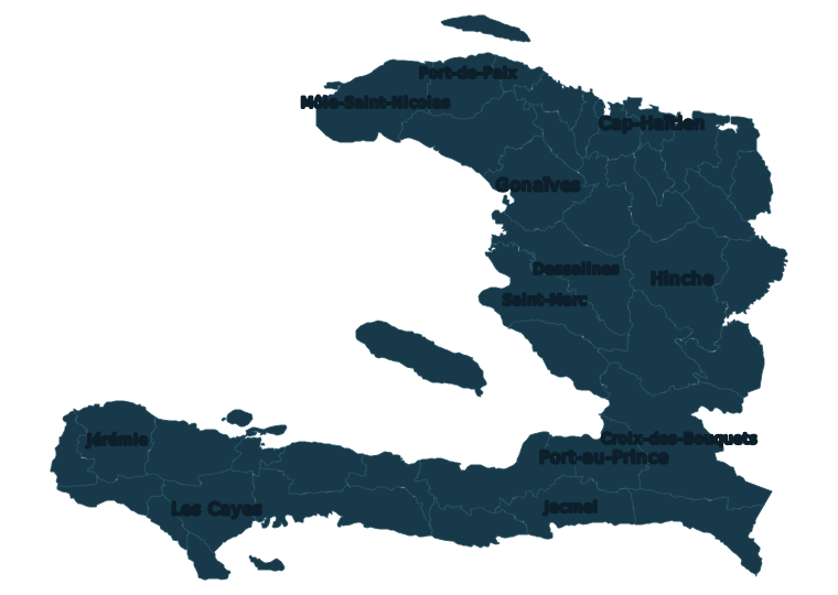
What Sentry View covers in Haiti
Haiti has had full coverage since launch: security, incidents, humanitarian situations and politics, with territorial and route assessment. Every record is georeferenced and carries a category, the date of the event, a confidence level, a cited source, an estimated area of influence and the date of its last verification.
Four categories
- Security — clashes, kidnappings, extortion, sexual violence, security operations, arson, among others.
- Incidents — flooding, landslides, earthquakes, storms, power outages, fuel shortages, accidents.
- Humanitarian — displacement, disease outbreaks, malnutrition, child protection, education disruption, blocked humanitarian access.
- Politics — protests, elections, judicial decisions, legislation, armed-group territorial control, international intervention.
Three confidence levels
| Level | What it means |
|---|---|
| Confirmed | Verified by direct observation, or corroborated by two sources independent of each other. |
| Probable | A single source considered reliable, or consistency with other reports from the same area and time. |
| Unverified | Received and logged, not corroborated. This is the default: a report starts unverified and only moves up when something justifies it. |
Validity
Every territorial layer and every route segment carries an expiry: from 15 minutes for traffic status to 30 days for a stable territorial assessment, with 6 hours as the usual value for a zone. When a layer expires it is marked as “needs review” and stops counting as verified. The full criteria are in the methodology.
The 42 districts monitored
The operational map divides Haiti into its 42 districts (arrondissements), grouped by department. Reports are placed by their coordinates and counted in the district they fall in; a district can also carry an editorial profile. A district with no colour on the map does not mean it is safe: it means there is no data for it.
| Department | Districts |
|---|---|
| Artibonite | Dessalines, Gonaïves, Gros-Morne, Marmelade, Saint-Marc |
| Centre | Cerca-la-Source, Hinche, Lascahobas, Mirebalais |
| Grand’Anse | Anse-d’Hainault, Corail, Jérémie |
| Nippes | Anse-à-Veau, Baradères, Miragoâne |
| Nord | Acul-du-Nord, Borgne, Cap-Haïtien, Grande-Rivière-du-Nord, Limbé, Plaisance, Saint-Raphaël |
| Nord-Est | Fort-Liberté, Ouanaminthe, Trou-du-Nord, Vallières |
| Nord-Ouest | Môle-Saint-Nicolas, Port-de-Paix, Saint-Louis-du-Nord |
| Ouest | Arcahaie, Croix-des-Bouquets, La Gonâve, Léogâne, Port-au-Prince |
| Sud | Aquin, Chardonnières, Côteaux, Les Cayes, Port-Salut |
| Sud-Est | Bainet, Belle-Anse, Jacmel |
Port-au-Prince: traffic corridors
There is no automated traffic network for Haiti, so the traffic signal in Port-au-Prince is entered by hand. Seven main avenues are preconfigured as corridors:
- Route de Delmas — Delmas 2 → Pétion-Ville
- Nationale 1 — Carrefour Aviation → Croix-des-Missions → Bon Repos
- Bd. Toussaint Louverture — Airport → Nationale 1
- Route de Carrefour — Portail Léogâne → Martissant → Carrefour
- Av. John Brown · Panaméricaine — Champ de Mars → Bourdon → Pétion-Ville
- Route de Frères — Pétion-Ville → Frères → Tabarre
- Bd. Jean-Jacques Dessalines — Portail Saint-Joseph → Portail Léogâne
A Haiti moderator picks a corridor, chooses its status (free-flowing, moderate, slow, congested, stopped or closed), the direction and an optional note, and publishes. Each update is valid for 15 minutes; when it expires the corridor goes back to “no data” — never to “free-flowing”. Nobody’s position is sent, and no external provider is involved.
A corridor status describes traffic flow at the moment it was entered. It says nothing about whether the road is safe. Route and zone assessments are separate layers with their own confidence and expiry.
What a trial account sees, and what a member sees
Every new account starts with a 5-day free trial, with no card required. When it ends, membership keeps full access at US$18 per 30 days of access, with no automatic renewal.
| Included | Trial | Member |
|---|---|---|
| Map and recent public reports | Included | Included |
| Haiti and African regions | Included | Included |
| Complete history | — | Included |
| Exact location of every report | — | Included |
| Member maps and operational layers | — | Included |
| Risk zones and critical infrastructure | — | Included |
| Available public evidence | — | Included |
During the trial (the Viewer role), the position of each report is rounded on the server — the browser never receives the real point — and sensitive evidence is not shown. Members see the full public history, exact locations and the public evidence available. Operational content is reserved for the moderators of the region.
Where the information comes from
Every report states its provenance, and that provenance is shown on the incident card. There are four possible origins: direct observation (including aerial observation), a cited external source (always linked to the original), information received through direct contact (logged without identifying the sender), and automated news intake.
For Haiti, the automated intake reads headlines from a fixed set of outlets: Haïti Libre, Ici Haïti, Juno7, AyiboPost, Haïti Liberté, Le Quotidien 509, Haiti24 and ReliefWeb (OCHA). Headlines sit in a separate panel, clearly kept apart from verified reports, and are deleted after 60 days. A headline is not a report: it is a lead to investigate.
What you will not find here
- Locations of humanitarian organisations’ offices, residences or teams.
- Names of people who report, and anything that could identify them.
- Exact coordinates of reports for anyone without a verified account.
- Attribution of territorial control to groups or individuals, outside moderation accounts.
- Any report, zone, route or assessment on this page: it describes coverage and method only.
Two limitations shape how the map should be read. Coverage is uneven: there are more records where there is more connectivity and more sources, and the absence of a report does not mean nothing happened. And verification is documentary, not forensic: we do not perform image analysis or technical geolocation of received material. No decision that puts a person at risk should rest on this information alone.
Get started
See the whole platform before deciding: map exploration, reports and alerts, and a look at the main tools. No card required to start.
Questions, corrections or information: gerencia@sentryuav.app. See also Africa: security monitoring by country and the methodology.